Activity: trail cycling (bucket list)
Location: Cumberland, MD > Washington, DC
Distance: 191.0 miles/ 307.5 kilometers (mostly flat with gradual descent, a few climbs here and there)
Duration: 18:47 (14:01 rolling time)
Weather: warm, humid, partly cloudy, some rain at dusk, 60-82 degrees
Climbing: 1,883 feet (less than 10 feet of climbing per mile)
Avg HR: 131 (max 170)
Type: aerobic
In life, there are “bucket list” items: the things you want to do before you leave this mortal coil (and no, I’m in no hurry to do so). And riding the C&O Canal Towpath – the whole thing – in one day is one of those.
I hadn’t planned on doing this ride, in actuality. Yes, it’s bucket list material, but this year? Maybe, perhaps, but it wasn’t on the radar. And then my friend, Eric, said he had to scuttle plans to do the ride – all 184.5 miles, plus commutes to and from the start and end points – as our friend, Lane, was having knee problems. I expressed my interest, Eric asked, “how about next weekend?,” and the die was cast.
The ride is a bit of a logistical challenge. Being a one-way, point-to-point ride requires one-way transit to the ride start. Regrettably, Amtrak doesn’t handle bikes as baggage on the line that serves Cumberland (though I’ve heard that it’s not difficult to get a bike on the train on low-traffic weekdays), so we had to go with another route.
Luckily, Hertz offers one-way car rentals from DC to Cumberland, so that was the choice. Eric and I braved the Friday rush hour traffic out of DC (which cost us an hour of driving time), stopped at the wonderful 28 South restaurant in Hagerstown for dinner, and settled into our hotel room around 11:30pm – later than planned, but not too bad…
…except that our plan was to wake at 4:30 for a 5:30-something departure. We were well prepped: bikes packed with essentials (food, clothing, tools, tubes, toiletries), everything in order to roll in the morning. But waking at 4:30 was painful.
We rolled out of the Holiday Inn at 5:41am and made the short crossing to the start of the C&O Canal Towpath and the Great Allegheny Passage Bike Trail, the latter of which meanders to Pittsburgh (another time for that, I’m afraid). We snapped photos in the early morning light, mounted our bikes, and left.
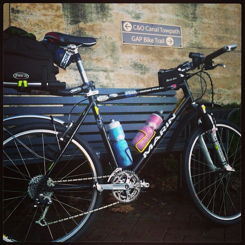
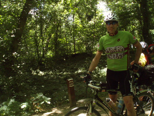
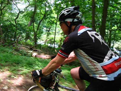
I chose to ride my 16-plus year old Marin mountain bike (named “Skully” because of a foam skull sticker on its head tube) because it offered more rugged components, the ability to run wider tires (1.5″ slicks), and front suspension – all reasonable considerations when the rolling surface is a dirt trail, with mud holes, crushed stone, bumps, tree roots, and other things that make it a bit less smooth than my usual paved routes. Equipped with a seatpost rack and rack trunk, it was suitable for the task.
The C&O Canal Towpath is a curiosity, one that only had a short usable life as a commerce channel before the railroad made it obsolete. It only exists today because of the intervention of Supreme Court Justice William O. Douglas, whose love of the towpath prevented it from being converted to a parkway, instead becoming the Chesapeake and Ohio Canal Towpath National Historic Park. The National Park Service provides upkeep over the full 184.5 mile run of the towpath, repairing flood damage and keeping it passable.
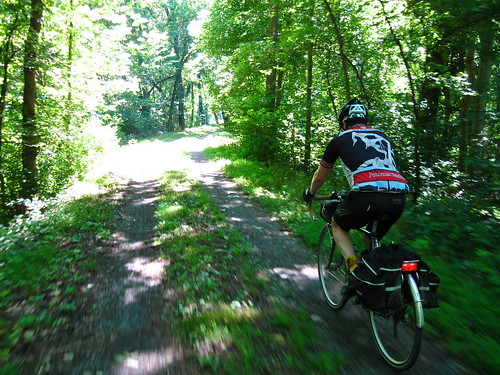
The first 30 miles showed the side-effects of this area’s ongoing rain: a lot of mud. It wasn’t impassable, but it made the going a bit slower than we planned. Our “timetable” had us averaging 16 mph for the ride, and we were mired, as it were, at 14 mph. It wasn’t a big deal, but it did make a mess of things.
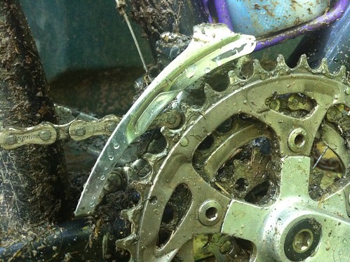
I was glad I brought the mountain bike, as its drivetrain was tolerant of a bit of mud and other muck from the trail.
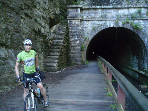
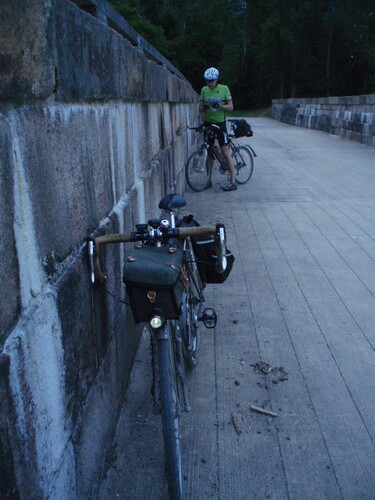
We eventually arrived at one of many engineering marvels of the towpath: the Paw Paw Tunnel. This tunnel cut the journey on the canal by over six miles. It was also a dark, eerie place to ride a bike.
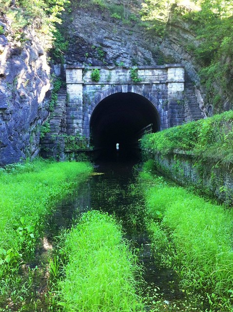
The path through the Paw Paw Tunnel is narrow and bumpy. Headlights are a must if you plan on riding in the tunnel, as it is extremely dark inside. We both made it to the other side without incident. Once there, you emerge onto a boardwalk and can see where a rockslide blocked the east portal back in May.
From Paw Paw, we continued toward Little Orlean, where we stopped at Bill’s Place. Essentially the only hangout in the town, Bill’s Place is a bar, general store, restaurant, canoe rental, town meeting hall, etc. The owner is a nice, middle-aged guy, and the service comes with a smile. We spent some time on the porch here, enjoying cool beverages and salty snacks.
From Little Orlean, we rolled toward Hancock. As the towpath was still muddy, we made the decision to take the Western Maryland Rail Trail to make up some time (I’ve ridden the stretch we skipped today back in 2011). Our average speed tipped up to 19 mph once we were on the WMRT, which was a nice boost. We saw many other cyclists on the trail, including a couple who were riding the full GAP-C&O length from Pittsburgh, albeit over multiple days. They were far more sane than Eric and me.
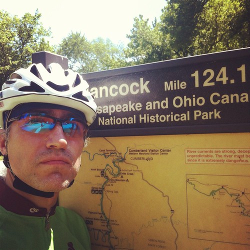
A quick stop in Hancock allowed us to top off our bidons and grab some snacks at C&O Bicycle. I also bought a bottle of chain lube here, as the mud and grime had already washed away the lube I’d applied to the bike on Friday. A quiet drivetrain was a nice thing.
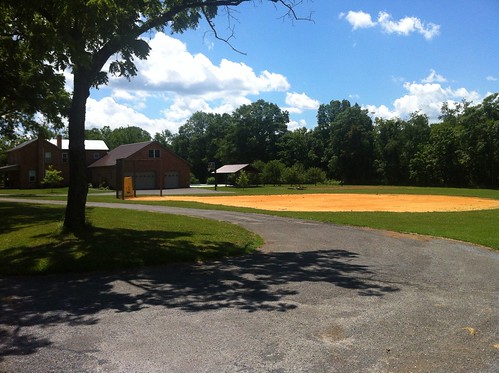
On the way back to the towpath, we took a wrong turn, adding a mile or so to our journey. However, we passed a house where the yard had been converted into a “field of dreams” baseball diamond, presumably for the family’s kids.
We did find our way back to the towpath, which wasn’t quite as muddy by this point but had its rough spots. The lovely thing about staying on the path is that there was shade pretty much everywhere. On a day that promised high temperatures near 84°F/26°C with ample humidity, it was a nice perk. The thick foliage did block some scenery, but not too badly: Big Pool was, indeed, big, and tough to miss.
So we kept rolling through the day. We had a lunch stop in Williamsport (a Sheetz MTO hasn’t tasted as good), where we saw a young woman catch her first fish in the lock pond, squeeing at it and shying away from removing it from the hook. We passed a tour boat on the canal. We saw more cyclists out on short trail excursions.
Outside of Sharpsburg and a little over 110 miles into our ride, we stopped at the quaint Barron’s Store & C&O Towpath Museum, a family-run outpost (literally run in what would be the living room of their house) that provided needed cold drinks and fresh fruit, as well as some indoor seating. Our legs still felt just fine (mine did, at least), but it was nice to sit back. A quartet of teenage boys rolled up to the store as we prepared to leave, each on a BMX or older mountain bike, reminding me of a hybrid of Stand By Me and Back to the Future in terms of “groups of kids on bikes, out having fun.”
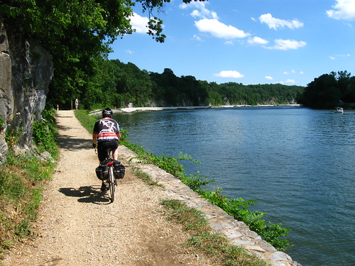
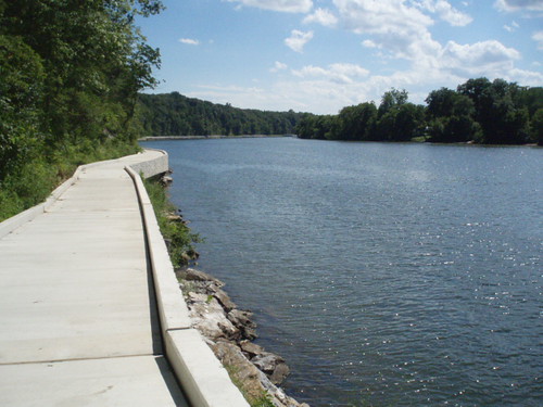
By this point, we were well behind schedule, but enjoying ourselves, all the same. Soon after Barron’s Store, we approached a section that Eric believed to be closed: the Big Slackwater viaduct. This wonder of civil engineering replaced a portion of the towpath that settled into the Potomac, and it was a joy to behold – and to ride! It was one of the more exposed areas of the path, clinging to the side of a sheer rock wall, and as we passed a group of boaters taking a dip in the water, we were tempted to jump in….
We soldiered on with an increased tempo at this point, past Sherpherdstown and Harper’s Ferry, toward our dinner stop in Brunswick at the wonderful Beans in the Belfry coffeehouse. A Celtic group was playing there, I and recognized the lead singer and guitarist from Falcon Ridge Folk Festival (he didn’t recognize me, which is all well and good). Eric and I noshed on spinach quiche, and also took advantage of the nice bathroom to wash our faces and brush our teeth. The cleanup had an amazing energizing effect, which was good, as we saw dark clouds approaching as the daylight grew long. As a nod to the weather gods, we donned our cycling caps under our helmets to ward off the rain.
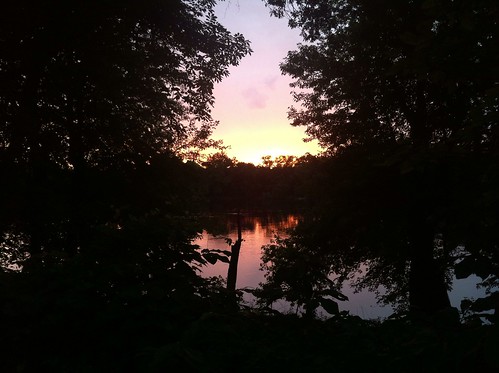
Getting back onto the towpath, we increased our pace yet again, taking advantage of a smoother section of trail to try and make as much progress as possible before the sunset. We made it to Mouth of Monocacy rather quickly, stopping briefly to snap a picture from within the aquaduct, looking toward the setting sun.
A little further down the trail, we found an even better view of the sunset, near Dickerson:
It’s at this point that our cycling caps ran out of good mojo, and we experienced our first rain of the day. We weren’t sure whether it would be heavy, as the clouds looked very black. We decided to carry on to White’s Ferry and make a decision whether to stay on the towpath and risk the mud, wind, and rain, or to take the well-known paved roads down to Riley’s Lock.
Luckily, the rain stopped about 1/2 mile before we pulled into White’s Ferry. At the ferry store, we bought some cold sodas and talked with the ferry operator, who deemed us crazy for wanting to carry on to DC along the towpath in the cover of darkness. We laughed, wished him well, and got back on the path.
Less than 1/4 mile from there, the battery on my Garmin Edge 500 died. It had sent out a warning beep a little while earlier, but as my unit has a blown-out screen, I had no way to verify that the beep was battery-related (though I suspected that it was). It did well for an older unit: 15.5 hours of runtime. Luckily, my phone had a decent amount of charge, so I swiftly started the Strava iOS app, missing only 0.1 miles of tracking (easily connected when I combined the two GPS tracks).
As we rolled along, there were frogs all along the towpath, their song growing louder as we rode deeper into the woods. The amphibians would jump out of the way just in time as we rolled. Our pace was slower, but our lights allowed us to find safe passage. The towpath started to have more muddy patches as we neared DC, so our lines had to be chosen more judiciously. When we passed one of the lockmaster’s houses, the group staying there was making s’mores over an open fire – and we were quite tempted to join them and crash there for the night.
We also weren’t sure where our next known landmark, Riley’s Lock, was. Yes, we had the mileposts to go by, but we weren’t sure where Riley’s was in the grand scheme of things. This added an eerie quality to this section of the ride, and while we weren’t necessarily physically fatigued, this added to our ever-growing mental fatigue. At least the frog song was there.
At this point, we made a decision: due to our growing mental weariness, we would exit the towpath at Great Falls. The stretch from Great Falls to Fletcher’s Lock features a good deal of technical trail: mud, ruts, damp boardwalk, things that require full mental faculties to navigate in the dark. It wasn’t that tough a decision: safety trumps stupidity. And both of us had tackled this stretch many times before, so it wouldn’t be big loss to skip.
So we stopped at the restrooms at Great Falls, let our significant others know that we would be getting onto MacArthur Boulevard to complete the trek into DC, and climbed our biggest hill of the day. My legs were quite spry here, and I climbed the road quite quickly. I waited for Eric at the top, and enjoyed the light show put on by thousands of fireflies in the trees over the Great Falls access road.
Once on MacArthur, we made decent time: nothing approaching my typical Wednesday night club ride, but still a good clip. We wound our way to Georgetown, took a left on 35th Street, wiggled to 34th Street, then made our way back down to the towpath for its final 3/4 mile to its origin.
We stopped, took photos, congratulated ourselves on a bucket list task now complete. I was confused by a text I received from sprite, saying she had refreshments in the parking lot – I was unable to remember that there is a parking lot by the Watergate, only 1/4 mile from where we were. We turned toward The Burrow, up the Rock Creek MUP. I stopped my Strava app, sat down, and I was done.
So what would I do differently? I’d like to do this again – over a period of 2 or 3 days. I’d take a hydration pack to allow for easier drinking while on rougher surfaces. I’d use regular panniers that keep the center of mass low on the bike (read: better handling). I’d also setup a dynamo wheel to charge my lights, Garmin, and phone via USB (I have a dynamo hub that needs to be built into a wheel).
But I’m so glad I did this ride! Eric was a great riding partner, his experience with the DC Randonneurs giving him many bits of sage advice to help on such a long ride. We had a great time – what more can a guy want?


sprite
3 July 2013 — 13:03
It was great seeing all the pictures in one place (although I appreciated getting updates throughout the day via Twitter) and hearing the few details I’d missed out on.
And in retrospect, I should probably have called to tell you where I (and the food) was when you asked me if I was in the parking lot by our house. (Huh?) That should have clued me in that you were more tired than your text messages were letting on.
Kudos to a hard day of cycling and a bucket list item checked off.
John
9 October 2013 — 18:43
What an accomplishment! I just did the C&O Canal & GAP Trails… But it took me a week. Thanks for sharing!
Brian
3 June 2014 — 12:40
A group of us is attempting this ride June 14th of this year…I am looking forward to it more after reading your account. Thank you!
Timojhen
3 June 2014 — 20:39
Thanks for the detail! Excited about doing the trip this year – will be calling it a bucket list ride now! 🙂
David
8 February 2016 — 23:30
Great job. Plan on doing it June 19th.did it on June 21 2014 but had to bail out at Great Falls .lights went dead and no spares or charger. Have them now. Another 8 miles we would have had some light from adjacent canal road. Co rider took spill and cut his leg. He lost his balance going through deep mud rut while clipped in on pedals.met him on trail. I would love to have someone to ride last 35 miles from Whites Ferry.can’t wait. It is the longest day .I live in WV roughly halfway between DC and Cumberland so a hotel at both ends is in order for me.